Research NeedsRidge to River's planning process identified a suite of research needs, to strengthen resilience and clean water in the Mad River Valley.
|
The research needs that are outcomes of Ridge to River's two year planning process and included in our action framework are listed below.
|
Complete |
Funded / In progress |
Developing / Funds pending |
Concept / Unfunded |
Tracking ProgressWhile we've begun implementing changes on-the-ground and within the community, we don't yet have a way to track Ridge to River effectiveness. |
|
Enhanced Land Cover Data |
Existing land cover data is problematic for any analysis beyond that needing a coarse scale. In the MRV, this data is particularly problematic because foliage cover blocks true calculation of road square footage.
Enhanced land cover data will identify forested lands (potentially including differentiation of forested areas by species type), impervious surfaces (roads, driveways, parking lots, buildings) and agricultural lands, among other cover classes of interest to the R2R taskforce and local communities. This data is essential for tracking land cover changes over time to understand:
|
Municipal Planning AssistanceTo ensure Ridge to River continuity, we envision developing a suite of data processing and analytical tools that can be employed by municipalities and their partners to understand how severe storms and changes in land use and land cover affect community resilience. Ultimately this information could: i) inform land use planning and zoning decisions based on an improved understanding of stormwater dynamics in the watershed; and ii) support Ridge to River's education and engagement efforts by demonstrating how (and what) individual / collective actions can contribute to watershed resilience. |
|
Stormwater Runoff Modeling |
Development of a calibrated stormwater runoff model for the watershed. The model, once developed, will be useful for identifying potential flooding and damage outcomes arising from alternative input conditions. For example, adjusting storm size and intensity data would allow us to investigate outcomes from a specific event. Or, altering land cover data could show how those changes might affect stormwater runoff volumes.
|
Critical Areas Analysis |
Identification of sites within the watershed for restoration, mitigation, enhancement, and protection. In order to incorporate stormwater management into land use planning and zoning decisions, we need to understand what issues and opportunities are most relevant to the watershed and where they present themselves on the landscape. We aim to develop Geographic Information System (GIS) methods and tools to identify areas within the Mad River watershed that are key to current and future stormwater resilience. Building from the 2017 Watershed Consulting Associates analysis, we would: i) conduct a review of the relevant scientific literature to both identify appropriate factors to consider and their relative importance for determining stormwater resilience; ii) develop and document methods of analysis to ensure long-term relevance, usability and replicability; and iii) engage Selectboards, Planning Commissions, Zoning Review Boards and town staff to offer training opportunities in using the software and interpreting results.
|
Other Research Needs
Riparian Vegetation Gap Analysis |
Analyze gaps in riparian buffers ‐ woody vegetation along stream banks ‐ within the Mad River watershed to facilitate prioritization of landowners for outreach and implementation efforts. - underway by Friends of the Mad River & Central Vermont Regional Planning Commission, completion Fall 2017
|
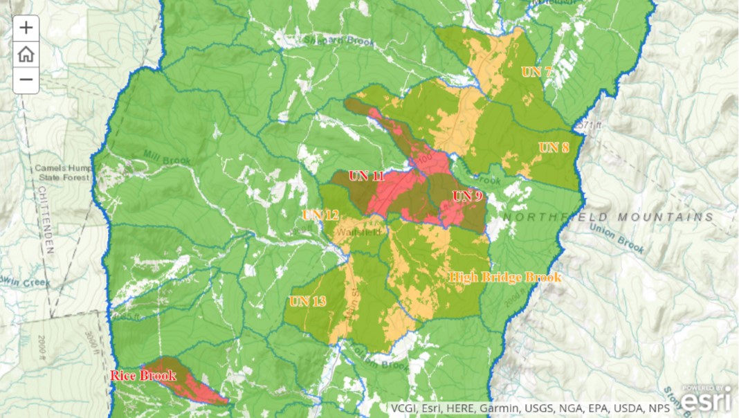
Shepard Brook Flood Study & Alternatives Analysis |
Waitsfield residences in Shepard Brook's alluvial fan suffer damaging and persistent flooding. This subwatershed may serve as a focal area for improving stormwater management upstream in an attempt to reduce downstream flooding. Also, building off a recent Central Vermont Regional Planning Commission flood study (not yet published), a Flooding Alternatives Analysis would look at the Shepard Brook and model the high flow events to help determine what areas are most vulnerable to flooding, the causes, and possible solutions to reduce risk to life and property.
|
Funding Clean Water & ResilienceAll the programs and projects outlined in Ridge to River's Action Framework for advancing resilience require significant resources. |

|
Stormwater Utility Model for Rural MRV |
Exploration of how a stormwater utility could work in the Mad River Valley to provide a reliable funding source for the MRV towns as they try to address the scattered, incremental development causing stormwater runoff problems for resilience and water quality. Most operating stormwater utilities are in urban or heavily developed suburban communities that experience much higher densities and greater commercial development, and associated impervious surfaces, than the MRV. With dispersed stormwater problems and an extensive rural road network, the MRV provides an opportunity to develop a model approach to establishing a stormwater utility in a rural setting.
Building on research undertaken by the Vermont Agency of Natural Resources, as well as work recently completed by Vermont State Treasurer Beth Pearce on strategies for funding Vermont’s water quality programs associated with Act 64, we will identify alternative methods for funding a multi-town, rural utility to address stormwater management and flood resilience. - Vermont Natural Resources Council (VNRC) will assist Ridge to River in this research in summer 2017 |