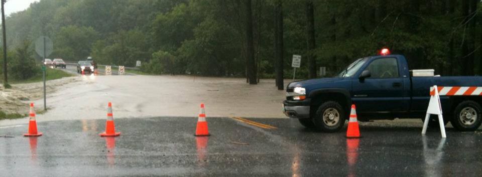
 Photo Credit: Jen Ryan Peterson for #madshedlove Winter Melt + Spring Rain = Time to Get Storm Smart! Heavy rainfall in the forecast and flood warnings starting tomorrow make today the day to get to work. Here are a few things you can do (in this beautiful weather!) to get ready for the storm; 1. Clean out the gutters on your buildings and make sure your downspout is directed somewhere stable. An energy diffuser, like a large stone placed under the outlet, can help reduce the velocity and concentration of water as it exits the gutter. 2. Clean sediment and gravel out of culverts AND clean debris out of drainage ditches. Clogged culverts are often a major culprit in damage from storms. When culverts gets backed up, the water ends up overflowing and impacting roads and driveways. 3. Clean and repair water bars, check dams, and other structures used to divert water. A little work in advance can save a headache later. Make sure that any drainage system has a clear, stable (either vegetated or stone lined) outlet. 4. Cover any exposed soil. If you have been out preparing the garden or have been working on a construction project and you have exposed soil, covering it up can help prevent erosion, downstream pollution, and save you from having to replace it later. 5. Get your umbrella, muck boots, and camera ready! One of the best times to observe how water moves across your property is to take a peak outside during a storm. Be aware of the risks if you live near stream or other flood vulnerable area – do not approach flooded roads or rushing water. If there is a chance of finding yourself in a dangerous situation, you’re probably better off watching from the living room window! 6. If you have any questions, please feel free to get in touch with Friends Storm Smart program (https://www.friendsofthemadriver.org/storm-smart) at [email protected] or at (802) 496-9127. 7. Schedule a Storm Smart assessment to be ready for the next storm! 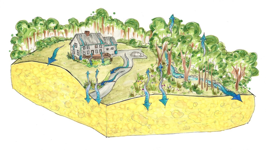  Beaver (Castor canadensis) swims across Blueberry Lake in Warren. VT The Mad River Valley runs north-south. It’s namesake river draws from the Green Mountains to the West and the Northfield range to the east before draining into the Winooski River. It has followed this path for thousands of years, only interrupted in it’s workmanlike carving of rock and soil by the grinding of glacial tides. The river and glaciers alike work ever downward, drawing out the sculpture hidden in the bedrock beneath. Ancient beds of mud, pressed under the ages, form veins of schist stretching the length of the valley. Crystal knobs of quartz betray phyllite plumes folded into the landscape. Bedrock arms lunge out from the mountains to cajole the river, here a dog-leg, there a gorge. As the Wisconsin glaciers ebbed, inching ever northward, they pushed and prodded cobble, silt, and sand. Frozen dams hid the river’s winding path beneath the depths of reservoirs whose shores remain, piecemeal, as sandy banks and gravel pits spread haphazardly along the valley’s contours. The dams burst and for 14,000 years the river and its tributaries have slipped through the seams of geologic history; the Mad has seen generations of lichen and moss give way to sedge and grass, it tributaries have arced the path by which boreal firs have grown as neighbors to maple and beech, its willowy shores have been the canvas for brook trout, blueberries, and beaver to paint the passing of their days. My first steps in the Valley happened sometime before I can remember, but through the years I have made memories of all kinds exploring its peaks and troughs. I lived most of my life along the Winooski but spent many summer days dipping my toes in the Mad. As luck would have it, I was given the opportunity to work with Friends of the Mad River a few years ago. 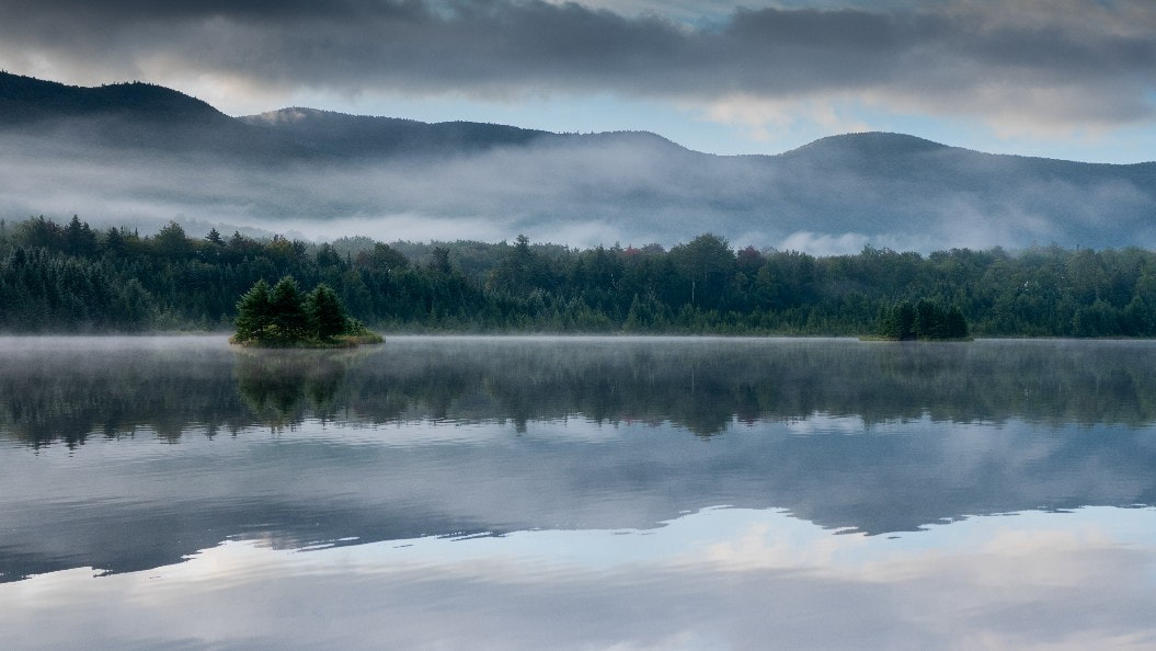 A pair of islands adrift in the morning fog in the shadow of the Northfield Range Since then, the Valley has opened up before me, idiosyncratic in its history of glacial lakes and steep, rocky slopes; its pastoral farmland and anachronistic villages; its young, low lying forests, and its ancient peaks of rugged spruce. It offers a layer cake of natural history, a true delight to explore. And though I might carve out my own path through these layers, there are many who have come before me - and each of us, in our own way, trace the path of water, whose often slow, yet sometimes sudden, etching of stone and soil marks our way. Yet, the water is so much more than a marker. It carries us in our canoes or on our skis; it flows between us and all our neighbors, the clouds above, the roots of trees, and the beer in our bottle; and so, the path water takes through the Valley is, in the most vital of senses, the path we all take through the Valley. As water works its way down steep slopes, it winds through leafy canopies, layers of humus, the mosaic of soils deposited in ancient lakes or dropped by glacial taxis, and inexorably downward to the very bedrock below. It is in our tributaries, in the outcroppings along the main stem, in the mighty limbs of ledge crisscrossing the landscape, that water reveals its most long standing sculptures. The smooth, whirling lines of this stone are evidence of millenia of eddies, currents of water trapped in brief whirlpools, again and again like the subtle chipping of the mason’s chisel. The course of the water shifts over time, giving way to harder stone here in favor of softer stone there. In this way, erosion reveals a story written somewhere between the tempestuous raindrops and the stoic folding of geologic time. At the southern tip of the Valley, small bogs and rivulets begin to form the very headwaters of the Mad, and the Granville Notch separates two very different stories. A drop of water that falls just to the south of the Mad River Valley might slip into the Alder Meadow brook to become part of the babbling chorus that joins the White River, then the Connecticut, and last, some two hundred miles as the cloud flies, flows out the estuary into the Long Island Sound. 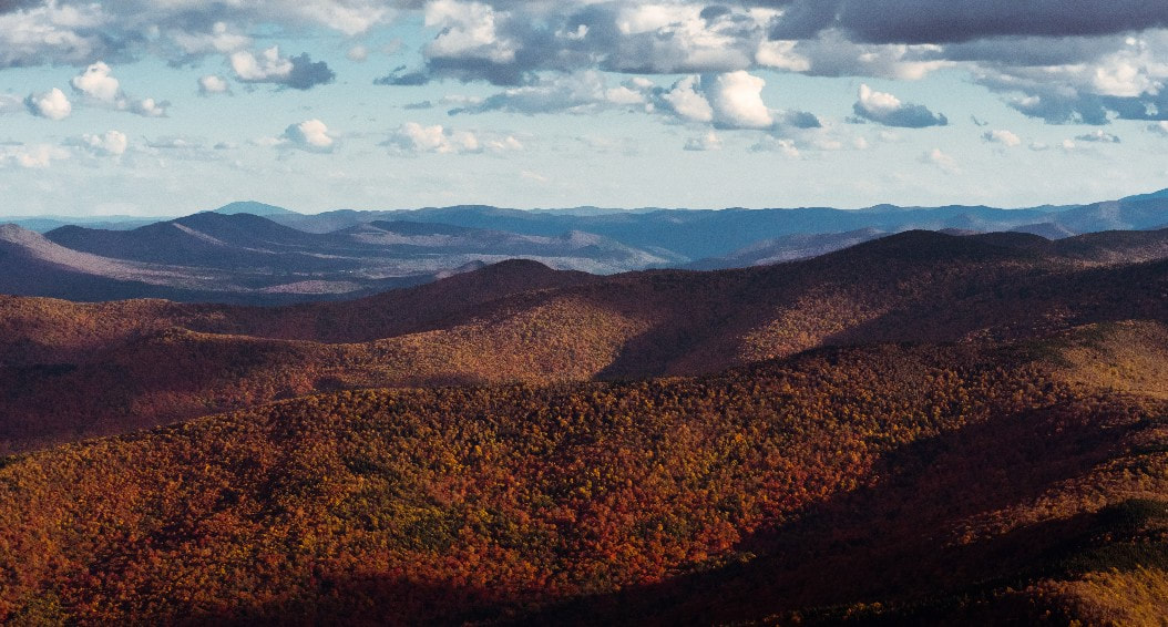 The southwestern border of the Mad River Valley in Fall  Lichen clings to a quartz outcropping high in the Green Mountains 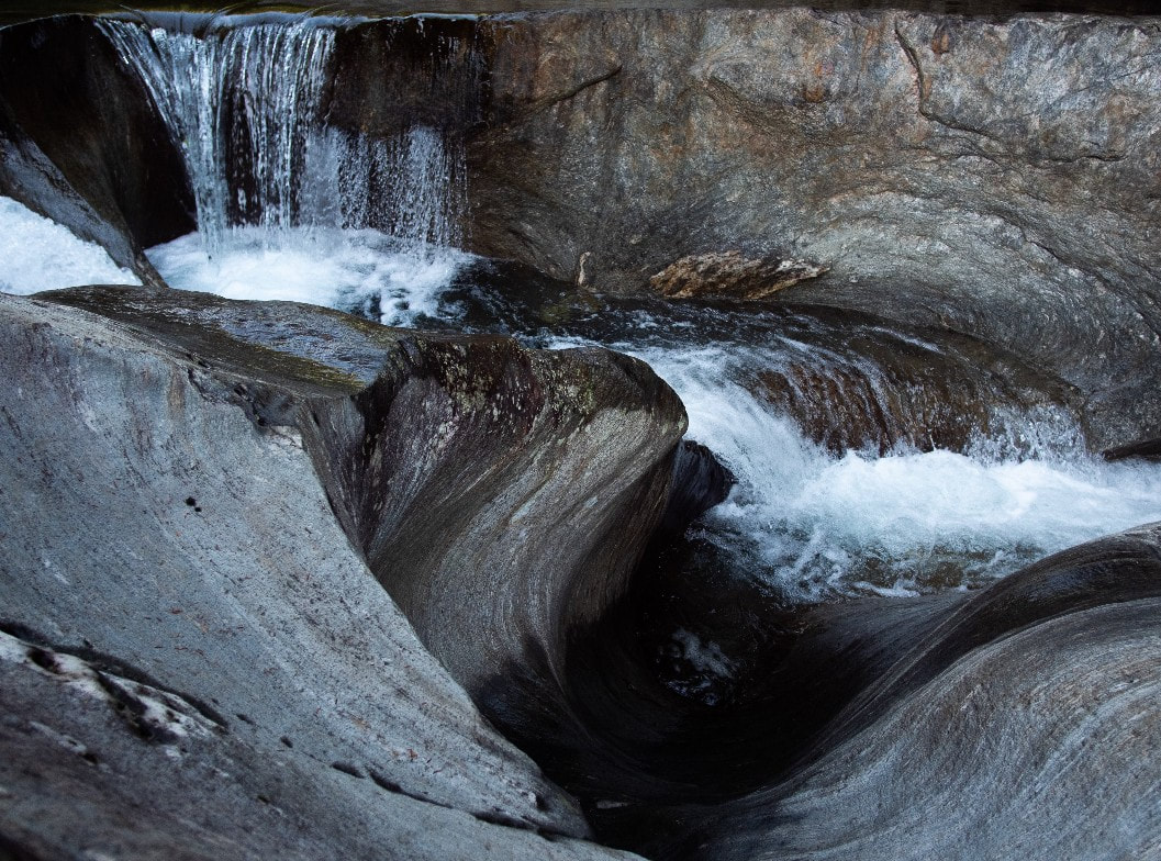 Ancient eddies carved in the rocks of Warren Falls For the water that lands just to the north, a different story unfolds. The headwaters of the Mad slowly build momentum, starting as little more than a stream, a few inches deep, and narrow enough to step across. A few little trickles here and there are followed by the drainage from Alpine Lake. Then the Austin Brook, its many little tributaries drinking up the water from the Green Mountain National Forest. Then Mills Brook, which is the drainage for Blueberry Lake, itself a catchment for the Roxbury State Forest. The Northfield Mountains cup the southern and eastern edges of Blueberry Lake. The gentle slopes give rise to modest peaks, though still enough to edge out the morning sun and allow cool air to roll banks of fog into the Valley below. The Roxbury State forest is both border and portal. Its broad, interwoven canopy stretches over the Valley walls and provides habitat and mobility to white-tailed deer (Odocoileus virginianus) and black bear (Ursus americanus) alike. Water that lands amongst the trees will slowly trickle down into the seams of bedrock. Then, moving at a snail's pace, it will eventually breach the confines of these hidden aquifers and spill out in seeps, streams, bogs, and even manmade lakes. In time, though, water that has not evaporated or transpired finds its way ever downward, ever seeking to follow the path the Mad has cut for ages. The Stetson Brook joins and the Mad becomes knee deep in places before plunging headlong through the whirled carvings of the Warren Falls. Then the Lincoln Brook, a steep confluence of tributaries from the Lincoln Gap, the runoff from the Long Trail, joins the Mad just before the Warren Village. The old Warren dam, one of many relics of an age of mills-gone-by, slows the bracing flow of the Mad to a crawl. Its banks stretch, widening like a deep breath, before the river leaps from the dam and careens through outstretched bedrock and bridge abutments. The Bradley and Clay Brooks run parallel, ski-like down the slopes of Lincoln peak. 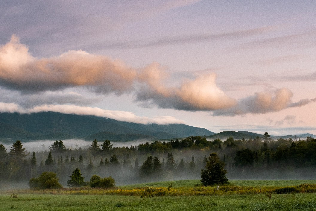 Fog clings to the valley floor By now the Mad is wide and deep, and in the summer full of swimmers and paddlers. The Mill Brook (not to be confused with aforementioned Mills Brook) is an amalgam of water tilting this side of the Appalachian gap merged with the Chase, Slide, and Lockwood Brooks. As the Mad widens, arcing serpentine along the Valley floor through the villages of Waitsfield and Moretown, it is urged on by the High Bridge, Pine, Shepherd, and Dowsville Brooks, along with dozens of other streams, all with many names lost and found to time, before losing its own name in the flow of the Winooski. But water is so much more than its destination. As the tributaries jostle their way through the layers of rock and soil, they often find themselves meandering along shelves, winding along the contours of lost lakeshores, or dammed by depressions in the bedrock below. Areas like these are often wet for most of the year and species like Sensitive Fern (Onoclea sensibilis) find their niche. Fossil records show colonies of Onoclea sensibilis in North America were present at least as far back as the paleocene, some 56 million years ago. As water pools and filters through the ground, the forest layers on generations of plants, fungus, bacteria, and animals. Each species reflects the slow transformation from bare, glacier scoured rock to the Northern Hardwood that blankets the Watershed today. Hidden away at the junction of woods, land, and water, the Northern Green Frog (Lithobates clamitans melanota) finds shelter among the club moss and sedges on a wet patch of ground high up in the Mad River watershed. A native, “true” frog, the green frog is an amphibian. Perched along the shore’s edge, they are quick to make their escape to the relative safety of the water. From their lodges and dams, to their buck teeth and wide, leathery tails, beavers (Castor canadensis) are unmistakable. But their charm is not in their looks and home decor alone. 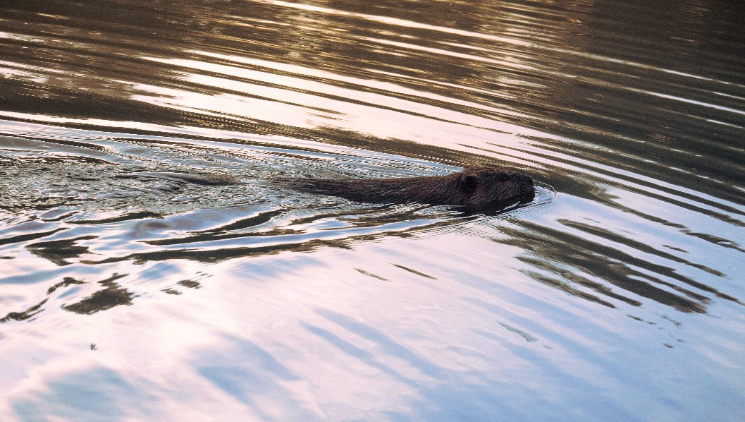 A beaver (Castor canadensis) cuts a path through the water just after sunrise. 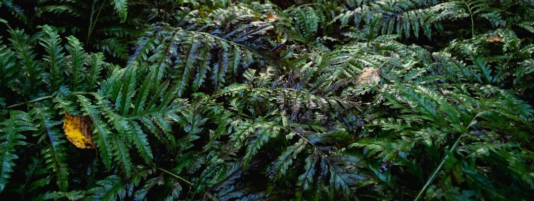 Sensitive Fern (Onoclea sensibilis) droops in the dampness of a cool morning 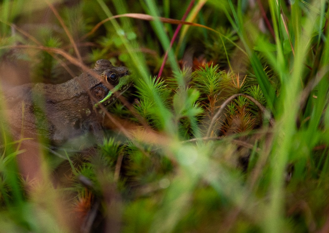 A Northern Green Frog (Lithobates clamitans melanota) keeps an eye out amongst the club moss Beavers shape the landscape around them in ways, perhaps, only matched by humans. By damming rivers they create biologically rich wetlands and ponds. They divert this water from its hard won course and force it to find a new path, a new inspiration for its work. Brook Trout (Salvelinus fontinalis) shunt and glide between shaded eddies throughout their lives. They migrate up and down the streams, their path dictated the presence of mountain springs, gravel bottoms, and overhanging branches. They are opportunists in diet as much as habitat, quick to lunge towards floating insects and occasionally even small fish. It’s little surprise that their orange bellies and speckled skin have become a welcome sight to fly fishers. Each fall, flocks of Canada goose (Branta canadensis) and turkey vulture (Cathartes aura) cross the sky, heading south against the grain of the river far below. Like the clouds that bring rain and snow, these patterns are marked by a presence in the natural systems that spill out beyond the bounds of the valley. Each fall, the leaves change color as the tilt of the earth points the northern hemisphere away from the sun. The shorter days grow colder, air grows more dense, and the long, grey cloaks of November, cloud the sky. Water clings to itself as frost that shines in the morning light. Soon there will be snow. Though the water will still flow, under layers of ice, through blue and white catacombs, heaving and falling through the course of the winter. And still on into spring and the return of the geese and vultures, the songbirds, and the awakening yawns of black bears. Before I know it, the summer days are on us like thunderstorms and I find myself standing knee deep in the Mad. 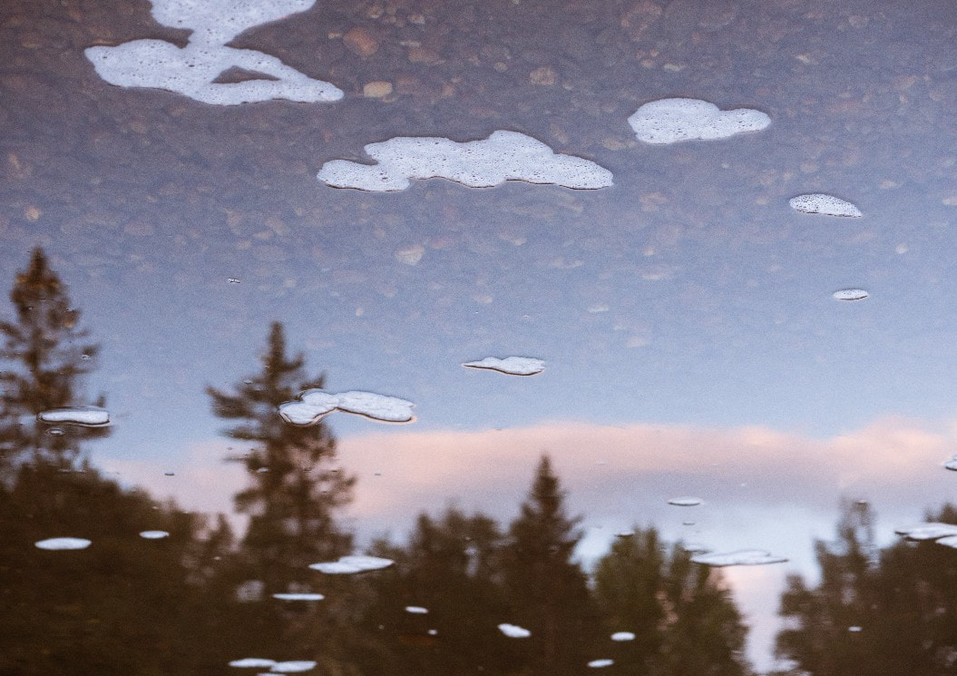 Clouds and foam caught between the river and sky The water moves around my legs and I can see the way it urges the Valley onward, carving and shaping as it goes, its gravity pulling the plants and animals, the people and their stories along with it. I watch as pollen and foam whirl in reflections of blue skies and leafy shores. I try and imagine what the Valley might have looked like to someone standing in that spot a thousand years ago. The ridge lines and bedrock outcrops would likely be the same, even as the twists of the river might spread far, lattice like across the valley floor. The sky would be just as blue, though there would likely be more birds across its firmament. And the nibble of fish, in all likelihood, would come more frequent to the toes. Would they feel the same shiver run along their skin, watching the wind ripple across the water, as a high cloud blocked the sunshine? What about the next thousand years? What meaning will the water of the Mad River Valley hold for the future? What will it wash away?
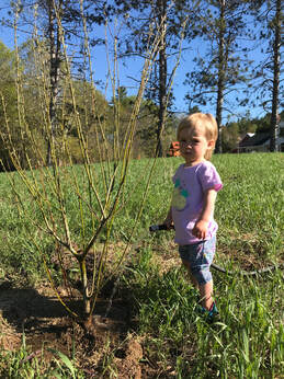 Little tree steward watering tree planted in support of wildlife connectivity. Little tree steward watering tree planted in support of wildlife connectivity. This article provides further guidance on what Valley residents can do to restore and protect biodiversity in their yards. It is a companion to the piece published January 13, 2021. The guide, a product of the Vermont Alliance for Half-Earth, is an answer to the call of biologist E.O. Wilson to preserve half of the planet for nature. The first article suggested the following strategies: Plant native species, remove nonnative invasives, reduce the size of the lawn remember that messy can be beautiful, stop using pesticides, leave the leaves and remember that dead wood is good wood. Here are additional steps to take to answer the half-yard call. Structural DiversityStructural diversity means having different three-dimensional shapes on the landscape. To increase the structural diversity, make sure to have plants of different heights, like big old trees, young trees or shrubs and herbaceous plants. If a tree falls in the woods, take the firewood, but otherwise leave it be. To increase the structural diversity, consider making a brush pile or a rock pile or dragging in some interesting logs and sticks. Mimic Old GrowthA fun way to think about creating structural diversity is trying to mimic characteristics of old growth forests. Old growth forests have big old trees and a well-developed understory, lots of standing and downed dead wood, tip up mounds and patches of young forest of different sizes and ages where wind storms created gaps. Habitat ConnectivityLarger networks of connected habitats support more species. This is because it’s easier for animals and plants to disperse through the landscape to find mates and sufficient resources. Whether in town or in the countryside, try to manage yards so the wildlife habitat within the property is connected to wildlife habitat on neighboring properties and across the road. Wetlands and Riparian BuffersIntact wetlands and riparian areas clean water, reduce flooding and support biodiversity. Naturally vegetated riparian buffers are also ideal corridors for wildlife movement because rivers and streams, stretch long distances across the landscape. View a soggy lawn as an opportunity to revegetate with wetland species and maintain or restore a buffer of native vegetation along streams and rivers. Messy is BeautifulNot everyone wants a messy yard. Here are some tips to make yards that are both aesthetically pleasing and rich in biodiversity: Use mown paths to connect areas of interest and use within the yard. Create a manicured look while using native plants. Use all the conventional landscaping techniques, like edging, designed plantings and mulching. Use the Garden Plant Finder! tool to find native ferns, flowers, shrubs, and trees of different colors and sizes. Planting flowers that bloom at different times makes for a flower bed or pocket prairie that’s pretty and good for the bees. Choose native ferns, spring ephemeral flowers and other shade-loving low plants like American wintergreen as ground covers instead of nonnatives like hostas. Rake the leaves, but spread them under nearby taller plants and into the wilder parts of the yard. Don’t deadhead flowers. Their seeds are important for winter birds, and their hollow stems are important for overwintering native bees. Try bunching them with twine or, at the very least, cutting them 8 inches off the ground. It’s okay keep some nonnative plants. It’d be hard to completely give up lilacs and apple trees. A recent study shows that breeding birds need a landscape with at least 70% native plants in order to find enough caterpillars to feed their young. Connect with the CommunityWorking towards Half- Earth, half-yard, or half-lawn for that matter, is an opportunity to support biodiversity and strengthen communities. By connecting with these community resources, people can help to support biodiversity across The Valley. Friends of the Mad River (FMR) can help through their Storm Smart program and Watershed Restoration efforts to improve flood resilience, protect clean water and foster wildlife habitat. Throughout the year, FMR works to monitor water quality, plant trees to restore riparian buffers and upland forest, steward swim holes and other community resources, and facilitates watershed-wide community discussions. The local conservation commissions play an active role in connecting local government to the conservation needs and opportunities on the ground. These commissions are often seeking volunteers. Right now, the Waitsfield Conservation Commission is seeking two new members. This article was written by Curt Lindberg with input from Friends staff and first published in the Valley Reporter on March 3rd, 2021
|
Friendsof the Mad River Archives
July 2024
Categories |
 RSS Feed
Proudly powered by Weebly