Friends of The Mad River
  • Home
  • Our Impact
    • Community Climate Chats >
      • Past Climate Chats
      • Climate Survey
    • Ridge To River >
      • Action Framework >
        • Programs
        • Research Needs
        • Resources
      • Planning Process >
        • Team
        • Landscape
        • Planning
        • Community
    • Storm Smart >
      • Storm Smart Assessment
      • Storm Smart Resources & FAQs
      • Green Stormwater Infrastructure & Best Management Practices
    • Tree Planting
    • Keeping Water Local
    • Mad River Watch >
      • Highlights from the Field
      • Volunteer Resources
      • Historical Data
    • Flood & Fish Friendly Roads
  • Get Involved
    • Events
    • Volunteer
    • Learn
    • Donate
    • Jobs
  • Who We Are
  • News
  • Contact Us
  • #madshedlove

The Water Column

Floods and Resilience: A "Flashy" River

8/27/2020

 
The 4th Article in Friends' 30th Anniversary Series

By Mary Gow

August 27 marks the ninth anniversary of Tropical Storm Irene. The Mad River is known as a “flashy” river -- the combination of steep terrain, thin soils and intense storms can cause the river to rise incredibly quickly, even if it’s only raining in one part of The Valley. The Mad River watershed, has a long history of damaging floods. The most recent -- June 1998 and 2011’s Tropical Storm Irene -- are among the top five highest levels of flooding recorded at the USGS gage in Moretown. During Irene, the USGS gage in Moretown rose from 66 cubic feet per second (cfs) to 23,600 cfs in under six hours -- a discharge even higher than the estimated highest during the historic 1927 flood. In The Valley more than 1,200 acres of farm and pastureland were damaged, about 200 homeowners reached out to the Federal Emergency Management Agency (FEMA) for aid, and local roads sustained expensive damage.

After the 1998 flood, Friends of the Mad River (FMR) produced a guide to Unmapped Flood Hazard Areas. Not only can the river and streams inundate and cause damage to infrastructure in the flood plain, they can take a totally new and unexpected path or dramatically erode riverbanks during floods due to the high velocity water.
Picture
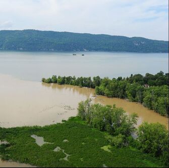
Photo Credit: Tropical Storm Irene Flooding - c. Lars Gange
River Science

Damage to the Mad River Valley from flooding is related to topography but also to the way people have historically manipulated the river channel – by straightening, damming and confining it with bridges, roads, villages and homes. River science has become the foundation for understanding where the river might move as it adjusts to equilibrium and anticipating how to avoid damage to infrastructure in its path. FMR worked with the Vermont Agency of Natural Resources (ANR) to produce fluvial geomorphological assessments that show how the river moves across the land, where it can access flood plains to disperse energy, and how wide the river corridor needs to be to allow the river to meander and adjust naturally. In the last two decades, Valley towns have developed flood overlay zoning districts in response to the information from these assessments and from revised FEMA flood plain and risk mapping.

Acknowledging Irene’s damages in August 2011 and implications for the future, FMR and its partners in the Mad River Valley Conservation Partnership, including Mad River Valley Planning District (MRVPD) and Vermont Land Trust, as well as ANR and town historical societies, hosted a symposium called “It’s a Mad River” in November 2011. Together, they shared the context and history of flooding, costs of Irene and stories of resilience. In a show of solidarity, the community volunteered about 15,000 hours to help neighbors clean up property and the river.

In 2013, working closely with FMR and MRVPD, the Vermont Agency of Commerce and Community Development, with federal funding, laid out four specific recommendations for long-term resilience in The Valley: conserve river corridors, protect vulnerable development, plan for future development out of harm’s way and implement stormwater runoff management across the watershed to slow, spread and sink rain and snowmelt.
Picture
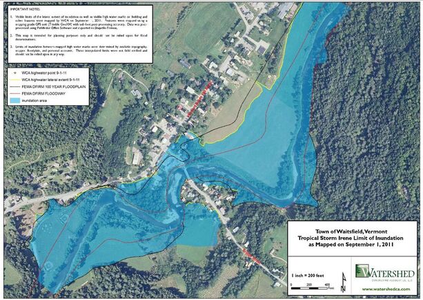
Map Credit: Watershed Consulting Associates
Better Management of Runoff

In 2015 FMR and MRVPD invited 20 community volunteers to participate at the 2015 Leahy Center Environmental Summit, where the group focused on strengthening The Valley’s resilience to future floods by better managing runoff.
A taskforce formed that later called itself “Ridge to River” and was comprised of
two representatives of the five watershed towns and led by FMR, with grants for its still-on-going work. “Better managing runoff is a way we can actually take our vulnerabilities into our own hands,” Corrie Miller, executive director of FMR, said. “With less water moving more slowly across the landscape before it enters
streams, our community will experience less flood damage.” The taskforce’s multiyear study and plan collected landscape, planning and community
data that highlighted needed protections of soils and forests, mitigations of
impervious surfaces and improved maintenance of transportation arteries like trails, roads and driveways.

FMR developed the Storm Smart program in 2017 to help landowners address some of the challenges identified by the Ridge to River taskforce. Through the Storm Smart program, property owners can get a free site assessment and suite of recommendations to enhance their home, driveway and yard’s ability to absorb storms. By making adjustments, each homeowner or property manager can lessen flood damage to downstream neighbors.

This story was originally published August 20th, 2020 in the Valley Reporter.

Caring for our Swim Holes

8/13/2020

 
Picture

​A message from Friends'
Board President, Kinny Perot

A few decades ago, when I was serving in the Vermont Legislature, a fellow state representative said to me, “Vermonters are the most generous people in the world ­– as long as you don’t force them to be.”

That seems to be true with all of us humans. We don’t like to be forced into doing something or behaving in any particular way, period. And yet, we are all connected just as the waters of this Valley, this watershed, are. If you do something on the ridges, it can, and usually does, flow downstream to the river. Certainly, the coronavirus has shown us that we are all intimately connected across the globe. What one of us does, can affect all of us.

And, while no one likes to be told they aren’t behaving, it seems we should sometimes speak up to be sure people understand that their actions are affecting us all. So, here I go, as a board member of Friends of the Mad River and as a member of the community, I am hearing more and more complaints about the condition of the swim hole access areas, about the use and abuse of them and how it has become too much for too many – landowners and users alike.

When the Friends of the Mad River published a conservation plan in 1995, it was clear that protecting the beloved variety of swim holes was of paramount importance to many community members. Nevertheless, a landowner had just closed access to a favorite site in Moretown, and many realized they had taken for granted that it was their right to use that land. Then the parcel was sold and a house was built, leaving the land unavailable to the public. Since then, Friends of the Mad River has worked hard to secure public access and, when possible, to ensure the swim hole areas dear to people are in public ownership. Take Warren Falls, for example. It took years of work to protect Warren Falls from development as a site for many houses. Now it is U.S. Forest Service property available to be loved and enjoyed by everyone. Unfortunately, it is being loved to death. There’s a lot of trash and noise, and the forest floor is trampled.

Other swim holes where Friends of the Mad River used to do water quality testing under the Mad River Watch program have been closed to the public for one reason or another. Owners have asked Friends of the Mad River to stop reporting the water quality results thinking, perhaps accurately, that seeing those sites listed in The Valley Reporter and on the FMR website was giving the public the impression they were advertised as spots to visit. Some landowners have closed access to dogs because of dog owners not cleaning up after their pets. Some sites are closed because visitors are leaving their trash behind, like dirty diapers, beer cans, glass and general garbage. Others are closed because some feel so entitled to use these spots that they build fire rings and start fires, or even set up tents and camp for the night, even on private property. Some visitors simply make too much noise for the nearby homeowners. Ultimately, land becomes posted when we mistreat it.

This summer has been unusually hot from my perspective, and I have never seen The Valley so packed or the swim holes so crowded. People are trying to stay cool and vacation closer to home, and it makes sense. But, the lack of care for these special places makes me, for the first time in my 41 years of living here, think of moving.

However, this is a community I love: I love the people, the forests, the streams, the river, the wild animals, the way of life. I even love the government here, both locally and statewide. I will never forget my first Town Meeting when two people vociferously spoke out on a topic, completely disagreeing and contradicting each other. I was stunned and found it rude, but later these two sat down to lunch together and were laughing. It opened my eyes to a different way of being. We can, with our different life experiences and varied solutions to problems, air our thoughts transparently. We can relate with one another not only with tolerance, but with respect. Let’s bring this spirit of community and comity to preserving our precious access to the river.

Can we instill this culture of tolerance or even go so far as to model respect – respect for the generosity of landowners who have allowed their community to use their land, respect for the other users of public or private swim holes by cleaning up after ourselves, giving others the space they need, deferring to those who got there first, or being sure to take turns? Maybe, and especially in these times, we could even go beyond basic kindnesses to express gratitude to those who make these treasured places available for our enjoyment and enlightenment. Maybe we could all get involved and help steward these favorite swim holes.

Perhaps the corollary to Vermonters’ being the most generous if not forced is that Vermont landowners are the most welcoming if their land is treated responsibly, with respect and the kindnesses of a guest.

“Freedom and Unity” is Vermont’s official motto. My vision is that we are all free to enjoy this place in our different ways and yet, we join together as one in our care and stewardship for it.

Originally Published August 13th, 2020 in the Valley Reporter
Photo Credit: Friends of the Mad River

30 Years of Swimming in the Mad

8/9/2020

 
​For the last 30 years, Friends has been working with community partners across the Valley to make sure that there are publicly-owned and permanently-permitted swimholes along the Mad and its tributaries. When the organization started there were only three such locations. Today, that number has doubled, and joins more than a dozen well-known places where people have enjoyed dipping their toes in the water to cool off on a hot summer day. 
 
A lot of work went into protecting public access to areas like the Warren Falls. But the work doesn't stop there. Through the years, publicly- and privately-owned swim holes have seen dirty diapers, trash dumping, unsanctioned rock moving and tree cutting. In the same way our community came together to protect these places, we need to bring the same spirit to the challenge of caring for them, so they can be enjoyed for the next 30 years (and 30 more after that!).
Picture

Friends & Swim Holes:
The 3rd Article in Friends'
30th Anniversary Series

By Mary Gow

Just three public swim holes. When Friends of the Mad River (FMR) was founded in 1990, there were three publicly-owned swim holes on the main stem of the Mad River -- the Picnic Area Cascades along Route 100 at the Granville town line, part of Lareau and the Kenneth H. Ward Access in Moretown. Every other one of 15 frequented spots was on private land, including Warren Falls. For a river identified in a Vermont Agency of Natural Resources study as “unquestionably one of the state’s best” in terms of number and quality of swim holes, public access was very limited. Private property owners’ generosity then, as now, was key to much enjoyment of the river.

In FMR’s three decades, publicly-owned and permanently-permitted access areas on the river doubled in number.

Increased access has been a team effort. Along with FMR, Valley towns, the state, Green Mountain National Forest, land trusts, local trail associations, businesses, MRV Rotary, Sugarbush Resort, individual property owners and others worked to provide these expanded recreational opportunities.
Picture
Photo Credit: Brad Long | Map Created by Jeff Schoellkopf and Sally Sweetland

​Visions for the River

One of FMR’s first initiatives was conducting public forums to get broad community input about residents’ visions for the river. A desire for high quality water, swimmable, even drinkable, topped participants’ lists. Another top priority was public access. Opportunities soon arose.

In the mid-1990s, the owner of property surrounding Warren Falls, who had posted the land to discourage trespassing, began plans for development there and listed his acreage for sale for over a million dollars.

FMR advocated for its acquisition by the Green Mountain National Forest. But there were stumbling blocks, including a $60,000 shortfall in funding. FMR helped bring The Conservation Fund into the process, allowing a stepped transition and launched a fundraising campaign.

“People came out of the woodwork to support it,” Kinny Perot, FMR board president recalls. “We had gifts from $10 to $10,000,” enough to meet the goal.

Lareau Swim Hole in the 1990s was public, but complicated. Right next to it sat a state-owned salt shed with stored road material. The 1998 flood made the situation precarious.

“It was deteriorated but still used, and the state planned to rebuild it,” recalls FMR board member Brian Shupe.

The Waitsfield Select Board and Planning Commission and FMR advocated for the state to tear down the shed, relocate the facility and turn the land over to the town. The plan succeeded and was followed by a state grant and community support for site design and landscaping.
​
Another product of the 1998 flood, Riverside Conservation Area in Warren was created with Federal Emergency Management Agency funds after the loss of homes on the site. FMR worked with the Mad River Path Association and the town of Warren on site layout and coordinated riparian buffer planting after the 1998 and 2011 floods.


In another collaboration, FMR, Mad River Path Association and individual property owners secured a permanent easement allowing access and establishing riparian buffers at the Meadow Road Bridge in Waitsfield.

FMR has partnered and advocated to preserve and enhance swim holes, improving access and also working to maintain healthy riparian buffers for wildlife habitat, clean water and flood resilience. FMR’s Mad River Watch has monitored water quality, educating the public about conditions that pose health risks for swimmers.
Picture

​Generosity

Acutely aware of property owners’ generosity when allowing use of their lands, FMR has endeavored to educate river users on respecting owners’ property and privacy, including in FMR’s publication “Caring for the River, Caring for the Land.”

“These energies haven’t stopped some beloved swim holes from being ‘loved to death,’” said Corrie Miller, FMR executive director. “Through the years, publicly- and privately-owned swim holes have seen dirty diapers, trash dumping, unsanctioned rock moving and tree cutting. I’m hopeful that the conversation bubbling up this summer about river access and trash at swim holes is an opportunity for our community to bring the spirit we used in securing access to swim holes to new challenges of caring for them, so they can be enjoyed through future decades.”

Originally Published August 9th, 2020 in the Valley Reporter.
Photo Credit: Toni Sosh for #madshedlove
<<Previous

    Friends

    of the Mad River

    Archives

    January 2023
    December 2022
    September 2022
    April 2022
    February 2022
    January 2022
    November 2021
    August 2021
    July 2021
    June 2021
    May 2021
    April 2021
    March 2021
    February 2021
    January 2021
    December 2020
    November 2020
    October 2020
    September 2020
    August 2020
    July 2020
    June 2020
    May 2020
    April 2020
    March 2020
    February 2020

    Categories

    All

    RSS Feed

Proudly powered by Weebly
  • Home
  • Our Impact
    • Community Climate Chats >
      • Past Climate Chats
      • Climate Survey
    • Ridge To River >
      • Action Framework >
        • Programs
        • Research Needs
        • Resources
      • Planning Process >
        • Team
        • Landscape
        • Planning
        • Community
    • Storm Smart >
      • Storm Smart Assessment
      • Storm Smart Resources & FAQs
      • Green Stormwater Infrastructure & Best Management Practices
    • Tree Planting
    • Keeping Water Local
    • Mad River Watch >
      • Highlights from the Field
      • Volunteer Resources
      • Historical Data
    • Flood & Fish Friendly Roads
  • Get Involved
    • Events
    • Volunteer
    • Learn
    • Donate
    • Jobs
  • Who We Are
  • News
  • Contact Us
  • #madshedlove