Friends of The Mad River
  • Home
  • Our Impact
    • Community Climate Chats >
      • Past Climate Chats
      • Climate Survey
    • Ridge To River >
      • Action Framework >
        • Programs
        • Research Needs
        • Resources
      • Planning Process >
        • Team
        • Landscape
        • Planning
        • Community
    • Storm Smart >
      • Storm Smart Assessment
      • Storm Smart Resources & FAQs
      • Storm Smart In Practice
    • Tree Planting
    • Keeping Water Local
    • Mad River Watch >
      • Highlights from the Field
      • Volunteer Resources
      • Historical Data
    • Flood & Fish Friendly Roads
  • Get Involved
    • Events
    • Volunteer
    • Your Mad River
    • Learn
    • Donate
    • Jobs
  • Who We Are
  • News
  • Contact Us

The Water Column

30 Years of Swimming in the Mad

8/9/2020

 
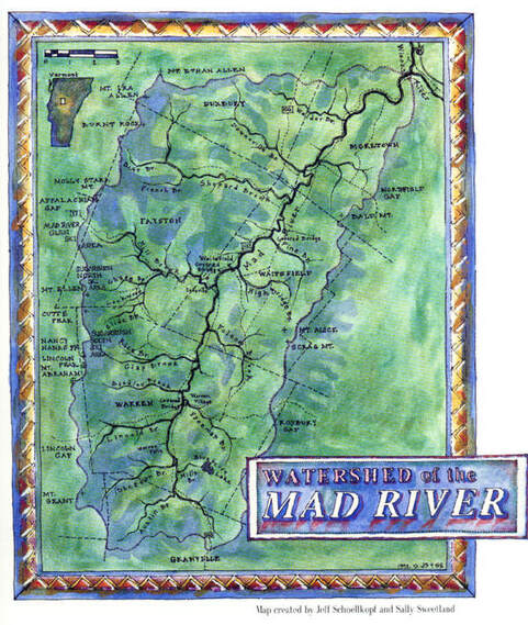
​For the last 30 years, Friends has been working with community partners across the Valley to make sure that there are publicly-owned and permanently-permitted swimholes along the Mad and its tributaries. When the organization started there were only three such locations. Today, that number has doubled, and joins more than a dozen well-known places where people have enjoyed dipping their toes in the water to cool off on a hot summer day. 
 
A lot of work went into protecting public access to areas like the Warren Falls. But the work doesn't stop there. Through the years, publicly- and privately-owned swim holes have seen dirty diapers, trash dumping, unsanctioned rock moving and tree cutting. In the same way our community came together to protect these places, we need to bring the same spirit to the challenge of caring for them, so they can be enjoyed for the next 30 years (and 30 more after that!).
Picture

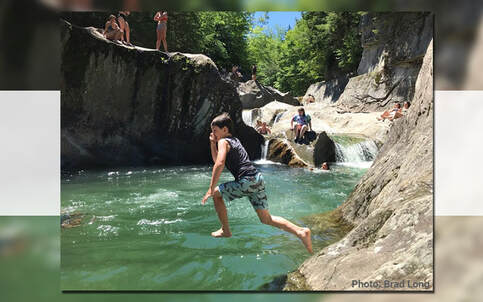
Friends & Swim Holes:
The 3rd Article in Friends'
30th Anniversary Series

By Mary Gow

Just three public swim holes. When Friends of the Mad River (FMR) was founded in 1990, there were three publicly-owned swim holes on the main stem of the Mad River -- the Picnic Area Cascades along Route 100 at the Granville town line, part of Lareau and the Kenneth H. Ward Access in Moretown. Every other one of 15 frequented spots was on private land, including Warren Falls. For a river identified in a Vermont Agency of Natural Resources study as “unquestionably one of the state’s best” in terms of number and quality of swim holes, public access was very limited. Private property owners’ generosity then, as now, was key to much enjoyment of the river.

In FMR’s three decades, publicly-owned and permanently-permitted access areas on the river doubled in number.

Increased access has been a team effort. Along with FMR, Valley towns, the state, Green Mountain National Forest, land trusts, local trail associations, businesses, MRV Rotary, Sugarbush Resort, individual property owners and others worked to provide these expanded recreational opportunities.
Picture
Photo Credit: Brad Long | Map Created by Jeff Schoellkopf and Sally Sweetland

​Visions for the River

One of FMR’s first initiatives was conducting public forums to get broad community input about residents’ visions for the river. A desire for high quality water, swimmable, even drinkable, topped participants’ lists. Another top priority was public access. Opportunities soon arose.

In the mid-1990s, the owner of property surrounding Warren Falls, who had posted the land to discourage trespassing, began plans for development there and listed his acreage for sale for over a million dollars.

FMR advocated for its acquisition by the Green Mountain National Forest. But there were stumbling blocks, including a $60,000 shortfall in funding. FMR helped bring The Conservation Fund into the process, allowing a stepped transition and launched a fundraising campaign.

“People came out of the woodwork to support it,” Kinny Perot, FMR board president recalls. “We had gifts from $10 to $10,000,” enough to meet the goal.

Lareau Swim Hole in the 1990s was public, but complicated. Right next to it sat a state-owned salt shed with stored road material. The 1998 flood made the situation precarious.

“It was deteriorated but still used, and the state planned to rebuild it,” recalls FMR board member Brian Shupe.

The Waitsfield Select Board and Planning Commission and FMR advocated for the state to tear down the shed, relocate the facility and turn the land over to the town. The plan succeeded and was followed by a state grant and community support for site design and landscaping.
​
Another product of the 1998 flood, Riverside Conservation Area in Warren was created with Federal Emergency Management Agency funds after the loss of homes on the site. FMR worked with the Mad River Path Association and the town of Warren on site layout and coordinated riparian buffer planting after the 1998 and 2011 floods.


In another collaboration, FMR, Mad River Path Association and individual property owners secured a permanent easement allowing access and establishing riparian buffers at the Meadow Road Bridge in Waitsfield.

FMR has partnered and advocated to preserve and enhance swim holes, improving access and also working to maintain healthy riparian buffers for wildlife habitat, clean water and flood resilience. FMR’s Mad River Watch has monitored water quality, educating the public about conditions that pose health risks for swimmers.
Picture

​Generosity

Acutely aware of property owners’ generosity when allowing use of their lands, FMR has endeavored to educate river users on respecting owners’ property and privacy, including in FMR’s publication “Caring for the River, Caring for the Land.”

“These energies haven’t stopped some beloved swim holes from being ‘loved to death,’” said Corrie Miller, FMR executive director. “Through the years, publicly- and privately-owned swim holes have seen dirty diapers, trash dumping, unsanctioned rock moving and tree cutting. I’m hopeful that the conversation bubbling up this summer about river access and trash at swim holes is an opportunity for our community to bring the spirit we used in securing access to swim holes to new challenges of caring for them, so they can be enjoyed through future decades.”

Originally Published August 9th, 2020 in the Valley Reporter.
Photo Credit: Toni Sosh for #madshedlove

Comments are closed.

    Friends

    of the Mad River

    Archives

    June 2025
    December 2024
    November 2024
    July 2024
    June 2024
    May 2024
    April 2024
    March 2024
    February 2024
    January 2024
    December 2023
    November 2023
    May 2023
    January 2023
    December 2022
    September 2022
    April 2022
    March 2022
    February 2022
    January 2022
    November 2021
    August 2021
    July 2021
    June 2021
    May 2021
    April 2021
    March 2021
    February 2021
    January 2021
    December 2020
    November 2020
    October 2020
    September 2020
    August 2020
    July 2020
    June 2020
    May 2020
    April 2020
    March 2020
    February 2020

    Categories

    All

    RSS Feed

Proudly powered by Weebly
  • Home
  • Our Impact
    • Community Climate Chats >
      • Past Climate Chats
      • Climate Survey
    • Ridge To River >
      • Action Framework >
        • Programs
        • Research Needs
        • Resources
      • Planning Process >
        • Team
        • Landscape
        • Planning
        • Community
    • Storm Smart >
      • Storm Smart Assessment
      • Storm Smart Resources & FAQs
      • Storm Smart In Practice
    • Tree Planting
    • Keeping Water Local
    • Mad River Watch >
      • Highlights from the Field
      • Volunteer Resources
      • Historical Data
    • Flood & Fish Friendly Roads
  • Get Involved
    • Events
    • Volunteer
    • Your Mad River
    • Learn
    • Donate
    • Jobs
  • Who We Are
  • News
  • Contact Us